MagSurvey
This real-time, map-based logging/plotting/retrieval magnetometer software gives the surveyor the full story of what anomalies are where, and in what direction they scatter -- without buoys, cord grids, or other references. Windows-PC-based, MagSurvey supports many magnetometers and requires a modern GPS receiver with full time differential corrections. Whether you are surveying for shipwrecks, pipelines, dump sites, or geological formations, MagSurvey is your best choice for boat-towed and land magnetometer survey software (Check out the new MagSurveyL for land surveys). MagSurvey now supports 800 x 600 screens as well as 1024 x 768.
THE NEW STANDARD FOR BOAT-TOWED MAGNETOMETER OPERATIONS. Now NEW and improved, NEW features and downloads.
![]()
NEW -- Version 1.3 with improved GPS performance and support for additional magnetometer models. Download free evaluation program -- See Ordering Information Page
![]()
Now in our twentieth year, Perception Systems stands ready to supply your needs for magnetometer surveying software with our current products for marine operations and our new beta evaluation versions for land operations.
| Quick Determination of Positions | |
| On-Screen Mapping | |
| On-Screen Magnetometer Graph | |
| Real-Time, Map-Based Plotting of Anomalies | |
| Easy Survey Storage | |
| Easy Survey Retrieval | |
| Easy Printing of Plotted Map | |
| Navigational Assistance | |
| Efficient Operation | |
| Easy to Learn | |
| Communications Support | |
| Post-Processing Support |
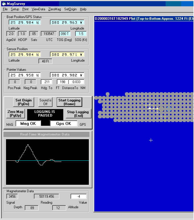
Main screen of MagSurvey 1024 by 768 marine version.
MagSurvey Features
QUICK DETERMINATION OF POSITIONS -- On-screen indication of sensor position and position of the user controlled pointer. Marine versions additionally display boat position. Pertinent differential GPS status information is also displayed on screen.
ON-SCREEN MAPPING -- The on-screen map operates with "map elements" based on lines of latitude and longitude. As with a nautical chart, the north-south dimension of a map element remains unchanged, while the east-west dimension decreases the further the surveyor is from the equator. Northwest is displayed at the top left of the screen in any hemisphere.
Versions On-Screen Map (Equator) Map Element (Equator) Map Element (Actual)
Marine Survey 1239 Feet Square Approx. 24 Feet square 0.004 Minutes of Lat/Lon
Land Survey 310 Feet Square Approx. 6 Feet square 0.001 Minutes of Lat/Lon
ON-SCREEN MAGNETOMETER GRAPH -- On-screen magnetometer graph displays recent anomaly status; adjacent windows display other pertinent magnetometer information. Audible bell sounds can be enabled to indicate when anomalies are sensed.
REAL-TIME MAP-BASED PLOTTING OF ANOMALIES -- Plotting of magnetometer-indicated peak anomalies occurs as the magnetometer sensor passes nearby, allowing for immediate and unmistakable scatter pattern determination. Map elements passed-through are indicated by gray octagons, making it unlikely that unknown holes will exist in the survey. The larger the gamma difference, the larger the displayed arrow pattern. Both positive and negative peaks are accumulated and displayed. Numeric values of positive and negative peak gamma differences are separately stored and can be read by moving the pointer over the map element.
| Positive anomalies plot as white arrow patterns pointing upward. | |
| Negative anomalies plot as yellow arrow patterns pointing downward. |
EASY SURVEY STORAGE -- Plots are easily stored to the hard-drive for future reference. The name of each stored file includes the date and time that the file was created and stored. This automatically sorts the files into chronological order by filename. Each stored file (.CSV) is approximately 49K bytes. If needed, bitmap (.BMP) files may be optionally created and stored from review mode, and offer advantages to printing the screen (these can be displayed and enhanced with Microsoft Paint and other similar programs). The optional .BMP files are approximately 1.4 megabytes each.
EASY SURVEY RETRIEVAL -- Stored plots and anomaly data are easily retrieved from disk storage and displayed in two different modes:
| Review Mode -- This mode loads an earlier survey for analysis. The current boat or operator position is superimposed onto the retrieved image, allowing efficient positioning directly above an anomaly without the use of buoys or markers. | |
| Append Mode -- This mode loads an earlier survey for the purpose of surveying areas not fully covered in the original survey. The saving of the new composite survey will be under the new date and time, leaving the original file undisturbed. |
EASY PRINTING OF PLOTTED MAP -- The plotted area of the screen can be printed to an attached color printer at any time during survey or retrieval modes of operation.
NAVIGATIONAL ASSISTANCE -- On-screen displays of boat distance and heading to any map element beneath the pointer, allow for easy return to any map element. With good judgment, this feature can also be used to facilitate the running of grid patterns.
EFFICIENT OPERATION -- Convenient grouping of plotting controls allows operation of the software by mouse or keyboard. This control grouping includes Zero Magnetometer, Set Origin, Start Logging, Stop Logging and Sound On/Off. this area of the screen also includes displays of overall Magnetometer status, overall GPS status, and status of Logging operation.
EASY TO LEARN -- Learning MagSurvey is made easy by the use of an on-screen manual (just click and press F1 in an area of the screen, or select the Help menu at the top of the screen). Further help is given by pointer-based descriptions of displays (just park the pointer over an item).
COMMUNICATIONS SUPPORT -- A pop-up screen can be selected to view the incoming messages from the magnetometer and GPS.
POST-PROCESSING SUPPORT -- MagSurvey's Review mode is all that most users will ever need for survey analysis. For those users with an interest in post-processing of data or comparison to sunspot activities logged by NASA and other agencies, MagSurvey's comma delimited .CDL survey data file can be read by spreadsheets such as Excel. The file has peak positive and peak negative differences, UTC times, and peak raw values; as well as depth, altitude, and "beenhere" information for each map element. The two raw peak values are stored as milliGammas (picoTeslas) -- all other MagSurvey values are expressed as Gammas (nanoTeslas). Header information displays the date and time of save, and the latitude and longitude of the upper left map element. The 2601 map elements are stored row-by-row in book form, with 51 elements across by 51 elements down. The center of each map element is 0.004 nautical miles from the center of each adjacent element for marine versions, and 0.001 nautical miles for land survey versions.
![]()
Perception Systems, Incorporated 8117A Northboro Ct, West Palm Beach, FL 33406
561-433-0033 Email: info@microcontrollersystems.com